


Aerial Recon LLC
GeoSpacial,
AERIAL PHOTOGRAPHY, LIDAR,PHOTOGRAMETRY, AND THERMAL IMAGING SERVICES
Animal/Pet Recovery
SERVICES

Drone Aerial Photography & Video
We specialize in capturing high-quality aerial photographs and videos using cutting-edge drone technology. Our services are tailored to meet the unique needs of each project, providing detailed and accurate aerial imagery for mapping and inspections. Weather you are looking for a high quality orthomosaic for a job sight or are wanting a promotional video for your business we can help. We can provide still photos as well. We can document the progress of sight from beginning to end.

Lidar Photogrametry Mapping
Our Geo spacial services include LiDAR and photogrametry mapping services. LiDAR and PG offer precise 3D modeling and topographic mapping for various industries. We utilize advanced LiDAR technology and PG technologies to deliver comprehensive data for infrastructure planning, environmental monitoring, and more. LiDAR utilizes lasers for precise calculations. This with ground base stations and RTK can provide highly accurate information for our clients. Photogrametry uses visible light to calculate and map terrain buildings and other surroundings. PG for clear areas, Lidar for areas with high vegitation.

Thermal Imaging
With our thermal imaging capabilities, we provide valuable insights for infrastructure inspections, energy efficiency assessments, and environmental monitoring.
Our thermal imaging services help identify potential issues and optimize maintenance strategies. We also offer services using thermal to help find lost loved ones or animals as well as livestock and wildlife assessments.

Aerial Recon is a leading provider of drone aerial photography services. We are the only one in the area that operates as a full time business, not part time like other operators. So we make the time for our clients. We are dedicated to providing our services like, lidar, photogrametry, and thermal imaging solutions for mapping, inspections, and infrastructure management. We also support our community by providing pet/animal search and recovery, insuring your loved ones or livestock are where they belong. We also provide wildlife and livestock management services utilizing our drones for highly detailed data.
Our team is dedicated to delivering accurate and actionable data to support various industries, including construction, aggregates, energy infrastructure, telecom, and more.
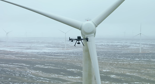
We can provide 3D models of Buildings, Wind Turbines, General Structures as well as Power Lines and Substations. We can also provide interactive 3D maps of construction sights taken weekly. This helps project managers stay current and plan ahead for their sights.
Area Served:
Based out of Cheyenne, Wy. we service Wyoming, Northern Colorado and Western Nebraska typically within 250 miles.
Outside of a typical range of 250 miles will be considered on a case by case basis.
Our vehicles are ready to tackle tasks off road with high clearance 4wd vehicles and the experience to get in and out of sights in the mountains of Wyoming and Colorado. We believe in protecting the environment so we tread lightly.
Industries Served

Construction
Aggregate Measurements
Energy Infrastructure (Transmission, Solar & Wind)
Telecom Infrastructure
Transportation Infrastructure
Oil & Gas Field (Compressor, Well, Pipeline)
Surface Mining
Public Land Management & BLM & Forestry
Commercial Businesses and Special Project Showcases
Lost animals/pets.
PAST PROJECTS


Current List of Equipment:
DJI Matrice 4E For Photogrametry Mapping
DJI Matrice 4T For Thermal Imaging
DJI Matrice 350 + R2A For Lidar Mapping
DJI Avata 2 For Interior & Fast Shots
Custom Built conventional helicopter for Large area NDAA Projects.
CONTACT US
Inquiries
For any questions about our services, don’t hesitate to reach out at your convenience. You can contact us using the phone number provided or fill out the form below. If you’re ready to schedule a meeting to discuss how we can assist you, please use the Book Online tab located at the top right. By becoming a member of our page, you’ll help us serve you better, You will also be provided access to communication platforms and file sharing.
Contact Us
Aerial Recon LLC
Trey Trainham Owner/Operator
Aerial Recon LLC
3404 Laramie St.
Cheyenne, Wy. 82001
Email: Trey@aerial-recon.biz
Tel: (307) 387-5252

Experience what we offer. Contact us for a Demo.

Join our team of dedicated professionals who are passionate about leveraging drone technology for impactful aerial data solutions. To apply for a career opportunity, please send your resume and cover letter to trey@aerial-recon.biz
Get a Quote: 307-387-5252